Editing Spatial Database Features
Once a connection to has been established to a spatial database, the Connections panel in the Map Connections dialog updates to show the features available for editing.
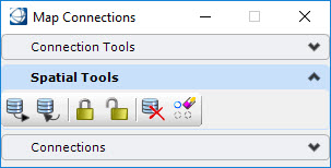
The tools for editing spatial features are found in the Spatial Tools pane:
The general process for editing spatial database features is to query the features from the database, lock those features to be changed, make the edits and then post the results. If the Map Manager is active, the model containing the spatial features being edited must be in the active model. If needed, use the Make Active for Edit to open the model containing the spatial features for editing.
|
Spatial Tools |
Operation |
|---|---|
|
Query |
Opens the Query Features dialog to perform a query. The last selected feature(s) will be active. |
|
Post Changes |
Opens the Post dialog. Posts modified feature instances to the database. The feature class and spatial extent must be selected. |
|
Lock |
Opens the Lock Features dialog. Locks the selected features based on the selected spatial extent. |
|
Unlock |
Opens the Unlock Features dialog. Unlocks the selected features based on the selected spatial extent. |
|
Discard Changes |
Opens the Discard Changes dialog. Discards edits made to selected features and in the selected spatial extent. Applies to the current session only. |
|
Erase Cached Instances |
Opens the Erase Features dialog. Erases selected spatial features from the session based on the selected spatial extent. |


