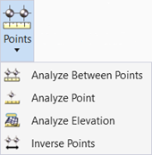
Inverse Points
 Used to compute and display the distance and direction between each pair of specified points.
You can access this tool from the following:
The Inverse Points tool computes and displays the distance and direction between each pair of specified points. Several types are supported: linear, arc, radial, perpendicular and by element. The tool is supported in both 2D and 3D views / models. The results are displayed at the cursor prompt, and optionally, the Civil Report Browser. Points may be selected graphically or typing in existing survey point names.
The active MicroStation symbology, text settings, and drawing scales are utilized for this tool. The direction values utilize the Design File Settings > Angle Readout settings for format, accuracy, and direction mode. The number of decimal places for the distance is determined by the Design File Settings > Working Units > Linear Units Accuracy value. The layout and content of the annotation is not user-definable.
Order is important as the direction is computed from the first point to the second point. Options Common to all Input Types.
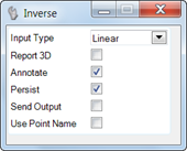
The following options are supported for all Input Types. Note these must be set within the tool settings, as there are no heads-up prompts for them.
|
Option |
Description |
|
Report 3D |
When toggled on, the display and annotation includes the horizontal distance, direction, slope distance, and delta elevation between the two points. When toggled off, only the horizontal distance and direction are displayed. |
|
Annotate |
When toggled off, no annotation is displayed and only the element (based on the input type) is displayed. When toggled on, the annotation is displayed. |
|
Persist |
When toggled off, the element (based on the input type) is displayed while the tool is active. After a reset, all elements / annotation are no longer displayed. When toggled on, the element / annotation is written into the active file and is visible after the command Is completed. In order to persist the annotation, the Annotate toggle must also be on. |
|
Send Output |
When toggled off, the output is displayed in the prompt fields and Civil Message Center. When Send Output is toggled on, the inverse points defined, the action of a reset opens the Civil Report Browser to the Inverse Report populated with the inversed points. |
|
Use Point Name |
In lieu of graphically selecting points, survey data points may be used. A mix of data points and survey points within a single tool is supported.Toggle on the option, then hover over a survey point, displaying its name. (If you already know the point name, there is no need to hover.) Type the name in to the field in the heads-up prompt or tool settings, then enter or tab to accept and move to the next prompt. The Use Point Name can be used with any input type. |
