Road
The Road placement tool follows AASHTO standards (class, design speed, default curve radius) and is created with the best fit on existing ground vertically.
When placing and modifying a road, superelevation is automatically calculated using AASTHO method 5, based on the road design speed.
When the design speed is <= 80km/h, the software uses the 6% table. The 8% table is used when the design speed is greater than 80km/h.
When the design speed is <= 45mph, the software uses the 6% table. The 8% table is used when the design speed is greater than 45mph.
Source: A Policy on Geometric Design of Highways and Streets, © 2011 by the American Association of State Highway and Transportation Officials.
From the Place Tools, selecting Road will start the place road tool.

- Click to place the first PI.
- Move the mouse and click again to place more PI as needed.
- To accept and complete the road placement, right-click. The road will be created.

Heads-up Display
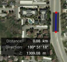
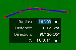
When placing a road, the heads-up display dialog appears. Pressing the tab key navigates between the different fields to edit the different values:
|
Radius |
The length of a line joining the center and a point of a circle. The value can be changed and by default, it is set to the minimum radius defined by the design speed. |
|
Distance |
The length between previous PI and the next point to be created. When moving the cursor, the distance value changes accordingly. |
|
Direction |
The angle relative to the last entered point. Format is in degree, minutes, seconds. The direction changes as you enter data points. |
|
Z |
By default, the "Z" value is the terrain elevation value. |
|
Profile |
Clicking on profile opens the profile view. For the Profile option to display, use the tab key 5 times. |