Importing Legacy Projects
The Geospatial XFM model offers many advantages not available in the legacy MicroStation GeoGraphics data model. OpenCities Geospatial Administrator uses schema promotion to convert a legacy GeoGraphics project to an XFM project. An XFM project effectively maintains spatial data with OpenCities Map. An XFM project describes the features, properties, placement tools, rules, and datasources for a project.
XFM features are created based on the name of the GeoGraphics feature. The symbology is identical. The level name defined in the XFM feature is based on the feature name. When importing a GeoGraphics project, evaluate how the features and capabilities available in XFM relate to projects and workflows. Some features may be consolidated using Property Based Symbology , accuracy improved using Property Based Annotation , or Domains and Adding Placement Metadata can be created and associated with features to improve speed and accuracy of entry.
While promoting a legacy project to a new XFM project is required, data conversion is not necessary to effectively use OpenCities Map. However, these tips may help create a better XFM project from a legacy schema.
- Define feature characteristics — OpenCities Map needs to know the type of feature (point, polygon) in order to create proper placement tools. Define the feature type in MicroStation GeoGraphics before importing. Test the workspace and make the necessary changes in the GeoGraphics model. Re-import until the desired XFM project is obtained.
- Have a complete feature definition — MicroStation GeoGraphics did not enforce a complete feature definition. Text sizes and fonts, cells to be used, and others were omitted. Because OpenCities Map uses a feature centric approach to building and maintaining features, make sure these types of feature attributes are defined before importing a project.
- Define level names to be the same as feature names — Matching level names to feature definitions was introduced in MicroStation GeoGraphics 2004 Edition. With XFM projects, this is important because it helps OpenCities Map recognize legacy and MicroStation features as valid XFM features through a mechanism called Dynamic Feature Scoring (DFS). This also makes using the project easier for users not using the XFM model.
- Adopt the XFM model for feature names — Feature names in XFM are composed of alphanumeric characters and are subject to restrictions. See Creating a Feature for XFM feature naming rules.
- Remove any custom commands from the UGCOMMAND table — By default, the project import tool creates Command Manager entries for each command it recognizes in the GeoGraphics feature command table. Since the new Command Manager table uses a feature based approach, remove any commands associated with an existing GeoGraphics features. Custom commands can be added later using OpenCities Geospatial Administrator.
To import a legacy project:
- Start OpenCities Geospatial Administrator.
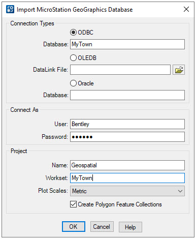
- Select File > Import MicroStation Geographics Database
- Enter the connection and login information
- Enter the Project information.
- Click OK.