Elevation Annotation Settings
In the Elevation Annotation Settings dialog, the following properties of annotation are defined in elevation drawing view.
| Setting | Description |
|---|---|
| Elevation Template | Sets the elevation template as defined in the grid template .dgnlib and by default the value selected is 'default'. |
| Display Label on Left | The display label is set on LEFT of an element based on either ON or OFF status of elevation drawing. |
| Left Label Target | It targets the position towards the LEFT or RIGHT of elevation grid line bubble. |
| Left Label Justification | Sets the position of label relative to it's origin either towards LEFT or RIGHT based on selection. |
| Display Label on Right | The Display Label is set on RIGHT of an element based on either ON or OFF status of elevation drawing. |
| Right Label Target | It targets the position towards the LEFT or RIGHT of elevation grid line bubble. |
| Right Label Justification | Sets the position of label relative to it's origin either towards LEFT or RIGHT based on selection. |
| Include Elevation | Sets the elevation level based on either ON or OFF status. |
| Use Relative Elevation | Sets the use relative elevation based on either ON or OFF status. |
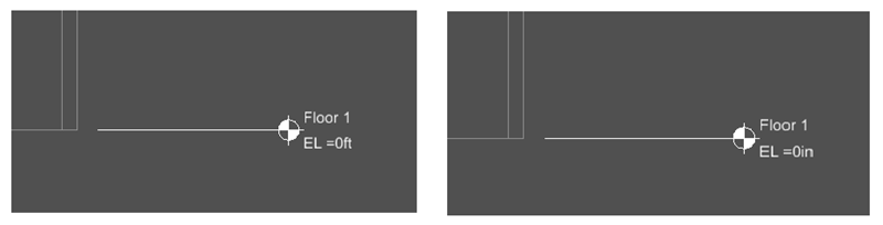
| Elevation Prefix | Displays the elevation prefix with elevation values, where EL= is a default prefix. |
| Elevation Suffix | Sets the elevation suffix. |
| Elevation Line Margin | Sets the margin between the element and grid line leader. |
| Elevation Unit of Measure | Sets the elevation unit of measure from the drop-down list as per user choice. |
| Elevation Unit of Display | By default it displays the abbreviation of selected Elevation Unit of Measure . |