| Source |
Lists the sources for the placemark. Following sources are available:
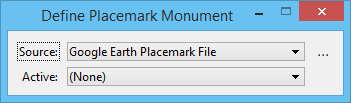
- Google Earth Placemark File — allows you to associate a geographical location from a Google Earth Placemark file to a Monument point in a model. To use this option, you must have created a Placemark file in Google Earth and then saved it as a KML type file.
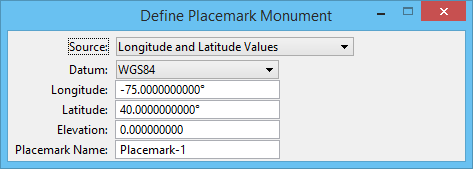
- Longitude and Latitude Values — allows you to input longitude and latitude values directly in the tool settings window and also select the datum. This placemark mode is appropriate when you have the longitude and latitude of building corners or other identifiable features in your design.
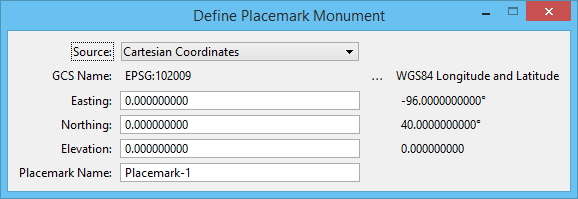
- Cartesian Coordinates — allows you to input Easting and Northing values in a given geographic coordinate system. This placemark mode is appropriate when you have the coordinates in a state plane (or similar geographic coordinate system) of building corners or other identifiable features in your design.
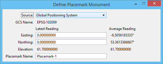
- Global Positioning System — reads a GPS device and uses the coordinates that it provides as the longitude and latitude for a placemark. To use this option, you must first start MicroStation's Global Positioning System interface using the GPS tool in the Geographic toolbox.
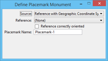
- Reference with Geographic Coordinate System — allows you to select an attached reference that has a geographic coordinate system.
Other options in the tool settings window change depending on the type of source selected.
GOOGLEEARTH
PLACEMARK
DEFINE
FILE
GOOGLEEARTH
PLACEMARK
DEFINE
DATUM
GOOGLEEARTH
PLACEMARK
DEFINE
CARTESIAN
GOOGLEEARTH
PLACEMARK
DEFINE
GPS
GOOGLEEARTH
PLACEMARK
DEFINE
REFERENCE
|
| Active |
(Google Earth Placemark File only) Displays the name of the currently active placemark; the option menu allows you to select a different placemark. |
| Browse for Placemark |
(Google Earth Placemark File only) Opens the Select Placemark Files dialog, which allows you to select a placemark file. |
| Datum |
(Longitude and Latitude Values only) Select the Datum for the placemark. If the Datum selected is other than WGS84 (the default), the tool settings window displays the WGS84 longitude and latitude values that are computed from the Longitude and Latitude entered in the respective fields. |
| Longitude |
(Longitude and Latitude Values and Global Positioning System only) Type the longitude value for the placemark. |
| Latitude |
(Longitude and Latitude Values and Global Positioning System only) Type the latitude value for the placemark. |
| Elevation |
(Longitude and Latitude Values and Goal Positioning System only) Type the elevation value for the placemark. |
| Placemark Name |
Type the name for the placemark. |
| GCS Name |
(Cartesian Coordinates only) Displays the coordinate system selected. Clicking the browse icon next to it opens the Select Geographic Coordinate System dialog. You can the select the geographic coordinate system in this dialog. |
| Easting |
Type the Easting value for the placemark. |
| Northing |
(Cartesian Coordinates only) Type the Northing value for the placemark. |
| Readings to Average |
(Global Positioning System only) Enter the value of readings to average. This setting is provided to minimize the errors due to "noise" in the GPS readings. It should be between 1 and 20. |
| Reference |
(Reference with Geographic Coordinate System only) Select the reference with geographic coordinate system |
| Reference correctly oriented |
(Reference with Geographic Coordinate System only) If off, the geographic source reference is attached arbitrarily (for example, coincidentally). It indicates that the data in the master file is not correctly aligned with the data in the reference file, and thus two data points are required. The first data point is used to identify a known feature in the reference file. The longitude and latitude of the placemark are calculated from this point. The second data point is used identify the same feature in the master file and position the placemark. If on, MicroStation assumes that features in the master and reference file are already in alignment and only one data point is required. At that data point, the longitude and latitude values are calculated from the reference file and the placemark is positioned in the master file.
|