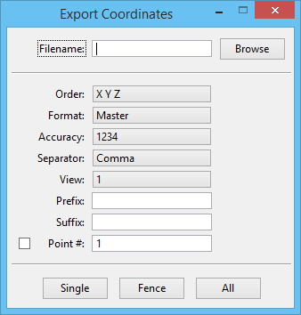
Export Coordinates
 Used to export coordinates of elements to an ASCII text file. When ACS Lock is enabled, the coordinates used by this tool are based on the Active ACS.
| Setting | Description |
|---|---|
| Filename | Lists the name of an ASCII text file to which the coordinates will be exported. |
| Browse | Opens the Create Export File dialog which allows you to select or create a file to which you can export the selected coordinates. |
| Order | Defines the order in which the coordinates are exported — XYZ or YXZ. |
| Format | Defines the coordinate format. Options are: Master, Sub, Working, and UORs. |
| Accuracy | Specifies the unit of accuracy for exporting the coordinates. |
| Separator | Defines the coordinate delimiter. Options are: Comma and Space. |
| View | Allows you to choose a view's orientation to display the point number if the Point # check box is turned on. |
| Prefix and Suffix | Allow you to add prefixes and suffixes to the coordinate string. |
| Point # | If on, consecutive point numbers are placed at the selected elements' coordinates. The point numbers also appear at the front of each coordinate string in the export file. The point number designated in the text field increases automatically and consecutively after you export the coordinates. |
| Single, Fence, All | Allow you to export single elements, selection sets, all elements in a fence, and all graphic elements in a design file, respectively. |