Geographic Coordinate System Dialog
 Used
to select a geographic coordinate system (GCS) from the library of predefined
geographic coordinate systems.
Used
to select a geographic coordinate system (GCS) from the library of predefined
geographic coordinate systems.
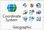
| Setting | Description |
|---|---|
| Details |
Opens the
Geographic Coordinate System Properties
dialog.
|
| From Library |
Opens the
Select Geographic Coordinate System
dialog.
Note: The
GEOCOORDINATE ASSIGN NOQUERY
key-in is typically used if no geographic coordinate system was previously
assigned to a file. It assigns the specified geographic coordinate system but
does not query the user, reproject, or change storage units. It can be used to
assign a geographic coordinate system if the storage units are correct. It
takes the value stored in your user preference file (*.UPF).
Note: The
GEOCOORDINATE ASSIGN REPROJECT
key-in reprojects the data to the new GCS. It assigns the specified geographic
coordinate system but does not query the user because it is not possible to
change units. This key-in reprojects a file from one geographic coordinate
system to another so the file must already have a defined geographic coordinate
system.
Note: The
GEOCOORDINATE ASSIGN MATCHUNITS
key-in corrects the GCS but does not change the data. It assigns the specified
geographic coordinate system and matches the storage units to those of the
geographic coordinate system but does not query the user or reproject. The
key-in assigns the geographic coordinate system to a file with units that
should be changed to match the geographic coordinate system. It is used when
units in a file are incorrect. A common case occurs in State Plane mapping.
Many users selected the feet units from
MicroStation. However, these feet
are international feet and the state plane coordinate systems are defined in US
Survey feet, a small but significant change over long distances. This key-in
changes the design file units to be correct for the specified coordinate
system.
|
| From Placemarks |
Opens the
Geographic Coordinate System From Placemarks
dialog. This tool is disabled if no placemark monuments are
in the active model.
|
| From Reference |
Opens the
Geographic Coordinate System From Reference
dialog. This tool is disabled if no reference attachments
are available.
|
| To Reference |
Opens the
Set Geographic Coordinate System In References
dialog. This tool is disabled if no reference attachments
are available.
|
| From File |
Lets you apply the GCS from a model in another design file
to your current file, even if it is not attached as a reference.
|
| Edit Reprojection Settings |
Opens the
Reprojection Settings dialog.
|
| Delete Geographic Coordinate System |
Deletes the geographic coordinate system attached to a
model.
|
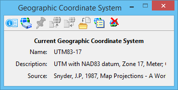
| Name | Shows the name of the current geographic coordinate system as specified in the library. |
| Description | Shows the description of the current geographic coordinate system as specified in the library. You can change this description from the Geographic Coordinate System Properties dialog. |
| Source | Shows the source of the current geographic coordinate system as specified in the library. |


