Geographic Coordinate System From Placemarks Dialog
Used to select a GCS defined by placemarks when using structure-centric coordinate systems. Geographic placemarks, cells containing a name, longitude, latitude, and altitude, indicate the geographic positioning of your design. The longitude, latitude, and altitude fields specify the geographic position relative to the WGS 84 datum, which is the datum reported by GPS devices and also used by Google Earth. The corresponding position in the design file is specified by the placement point of the cell. The scale and rotation of the cell does not affect its meaning as a geographic placemark.
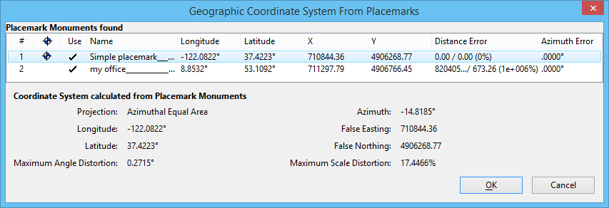
When provided with information about the geographic positioning of your model, an Azimuthal Equal Area GCS is calculated. At least two placemarks are required to calculate this GCS and should span the entire range of interest. Placemarks are created using the Define Placemark Monument tool.
A Geographic Coordinate System calculated from placemarks is only as accurate as the placemark data used to calculate it. If you use a calculated GCS to reference other geolocated designs, errors could be cumulative. Therefore, treat measurements between features in referenced designs as approximate.
| Setting | Description |
|---|---|
| Placemark Monuments found | Displays a list of placemarks in the model with the geographic and Cartesian coordinates for each. The most important placemark is used as the origin. The placemark with the dot in the second column is used as the center of the Azimuthal Equal Area GCS calculated from the placemarks. This can be verified by the values for Longitude, Latitude, False Easting and False Northing in the calculated parameters section. The Distance and Azimuth error columns give you a good idea as to whether the set of placemarks is internally consistent. Ideally, all of the error values are small. Maximum Angle Distortion and Maximum Scale Distortion provide the maximum distortion values occurring among the range of elements in your model. If the Maximum scale distortion is larger than .01%, or the Maximum Angular Distortion is greater than 2’, the area covered by the model is too large for an Azimuthal coordinate system to work properly. |
| Coordinate System calculated from Placemark Monuments | Displays the coordinate system calculated using the placemarks. |