Delineate Catchments
The purpose of Catchment Delineation is to analyse a terrain model, and calculate the area of it that will drain to a catch basin or a point. It is intended to be used with the final terrain model of the area to be served, which is normally the proposed design surface. Terrain models should be sufficiently precise that features such as gutters and swales are included, so that (for example) the valley formed by a gutter and curb is present, and contours clearly show this break line.
Note that gutter elements in the drainage model are not used in catchment delineation.
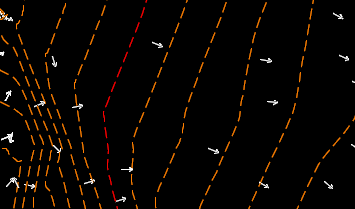
The catchment delineation tool works by first performing an upstream trace from the catch basin or point, until the trace reaches a high point. Additional traces are then performed until sufficient traces are available to complete a catchment boundary.
The catchment delineation tool cannot identify portions of the catchment that lie outside of the terrain model. The boundaries of this portion of the catchment must be identified with some other approach as it is considered a separate catchment. The outflow from this external catchment can be assigned to the same catch basin as that within the terrain model. The catch basin can have two catchments associated with it - one from within the terrain model and one from outside the terrain model.
There are several parameters that can be adjusted to improve the performance of the automated catchment delineation. These are described in the Catchment Delineation Settings topic
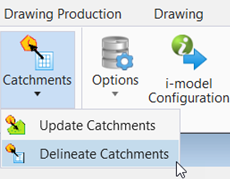
To delineate the catchment, follow the below steps:
- Select the Delineate
Catchment setting and provide the inputs as explained below.
Method: Select the method for delineating the catchment on a terrain model.
Grate Length: Enter the length of the catchment.
Grate Width: Enter the width of the catchment.
Feature: Select the appropriate feature definition for the catchment.
- Locate the terrain model in the .dgn file.
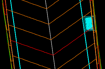
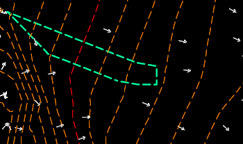
- Select the location
points where the catchment is to be delineate and the function will create the
catchment at that location as shown below.
In some places on terrain, a catchment may not be computed. In those areas, a message is returned to inform the user.

