Catchment Delineation Settings
Selecting Catchment Delineation Settings from the Terrain
manager opens the following dialog where the user can adjust parameters that
control the catchment delineation tool behavior.
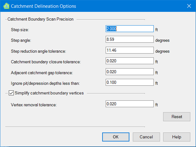
The default values for these parameters are usually adequate so the user should generally avoid changing them without good reason. The parameters are described below:
- Step Size: Step size is distance from the last found point to the next found point. A smaller search step will generate more accurate results, but it will increase the total time to search all points in catchment boundary. Range of the value is from 1 to 3 ft.
- Step Angle: Step Angle is the angle to rotate the line from the last found point to next point when trying to find the next point within the catchment or a point outside of the catchment boundary. Value can be 0.15 radiant / step.
- Step reduction angle tolerance: When a point is found in catchment boundary, the bend angle of the last found 3 points is calculated. If the bend angle is larger than the value, the search step will be decreased by half to find a more accurate point to replace the last found point. The step reduction angle tolerance value can be PI / 16 or 0.196 radiant.
- Catchment boundary closure tolerance: When a point within catchment boundary and a point outside of the catchment boundary are found, bisection method is used to find a point closer to the real catchment boundary. If the distance between the last found 2 points is smaller than the value, the search for the point will be stopped.
- Adjacent catchment gap tolerance: 3 lines with length of this value are drawn to the outside of the catchment boundary from 3 points in the line between the last found 2 points in catchment boundary (Fig. 9). By checking the ending points in the downstream trace paths from those 3 extended points, the program can tell if the gap is larger than gap tolerance. If the gap is larger than the gap tolerance, the search step will be decreased by half to find a more accurate new point to replace the found last point.
- Ignore pit/depression depth less than: We use terrain model downstream trace to check if a point is within the boundary of the catchment for the inlet. If the depth of the local pit is smaller than the value, the downstream trace will pass the local pit and continue to the downstream low point. For terrain models on road, the value can be between 0.01 ft and 0.1 ft. For natural surface, a relatively large value can be used.
- Simplify boundary vertices: If the box is checked, maximum perpendicular algorithm is used to reduce the number of points in catchment boundary.
- Vertex removal tolerance: When the distance from a point to the line between other 2 points is smaller than the value, the point can be removed from the catchment boundary point list.