Create Terrain
The Create Terrain
tool is available only when working in a three-dimensional model. Use this tool
to create a digital terrain model to represent a stratum found in the
boreholes.
To create a terrain object, the following properties need to be
defined:
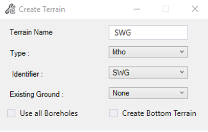
Terrain Name - User defined. The name of the terrain to be created.
Type - Comes from the database. Which property type will be used to create the terrain.
Identifier - Comes from the database. Which property will be used to create the terrain.
Existing Ground - Comes from the model. Select the ground terrain model. When a ground terrain is selected, it prevents triangle generation for the new terrain to be above the ground.
Use all Boreholes - When checked, automatically selects all loaded boreholes to create the terrain.
Create Bottom Terrain - When checked, the terrain will be created using the Bottom Depth of a layer instead of the Depth.