Compute Pond Volume
Compute Pond Volumes is a reporting tool that is used to compute volumes at different pond elevations. It uses two different methods to Compute Pond Volumes between terrain models.
You can access this tool from the following:
Ribbon: Terrain > Analysis > Hydraulics > Compute Pond Volumes
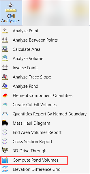
Ribbon: Home > Civil Analysis > Compute Pond Volumes
There are two different methods to create Compute Pond Volumes reports as explained below.
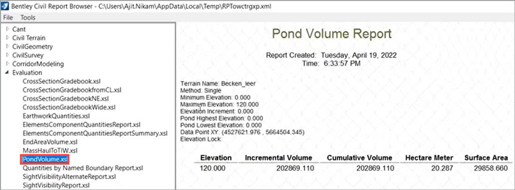
- Single Method - It will calculate pond volume at a single elevation.
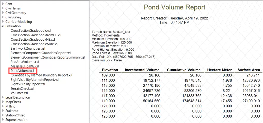
- Incremental Method - It will calculate pond volumes from the minimum selected elevation to the maximum elevation
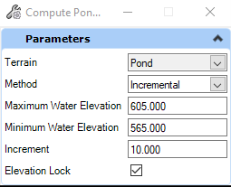
| Parameter | Description |
|---|---|
| Terrain | Allows you to identify work across a reference. |
| Method | Allows you to choose either the Single or Incremental compute pond volume method. |
| Maximum Water Elevation | Allows you to identify the upper elevation of the computation for either Single or Incremental. |
| Minimum Water Elevation | Allows you to define the lowest elevation to start the computation. |
| Increment | Allows you to set the increment value to the elevation. |
Elevation Lock: If Turned ON : The elevation for computing pond volume starts with the Minimum Water Elevation, increments to the next whole number using the specified interval, and ends with the Maximum Water Elevation.
For example, if the Minimum Water Elevation is set to 91.25, the Interval is set to 2, and the Maximum Water Elevation is set to 99.00, the increment would be 93.00, 95.00, 97.00, and so forth until it reaches 99.00.
If Turned OFF: The increment is set to the next number based on the Minimum Water Elevation. Using the same example, the increment would be 93.25, 95.25, 97.25, and so forth until it reaches 99.00. This option is available only when the Method is set to Incremental.
A sample of Compute Pond Volumes reports is given below.
Compute Pond Volumes report using the Single method.
Compute Pond Volumes report using the Incremental method.