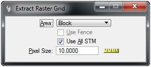
Extract Raster Grid
A portion of the STM can be extracted to a raster grid format. This format can be displayed with the Raster Manager tool Attach Raster Grid.
From the Edit menu of the STM dialog select Extract Raster Grid.
| Setting | Description |
|---|---|
|
Defines the area selection method: Block, Oriented Block, Element, Shape, View |
|
|
If a fence is active it can be used to define the area. |
|
|
Use all attached Scalable Terrain Models during processing. |
|
|
The pixel size for the output raster file. The measure tool can be used to select the pixel size directly from the view. |
Select points to define the area to be extracted based on the area type. The points must be selected in a top view. Any fence or shape should be in the plane of the top view.
The number of points selected will be calculated and a message displayed if the area is too large. In that case select a smaller area.
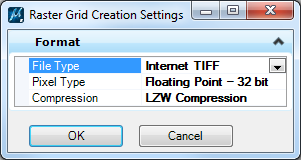
A dialog is displayed with the raster grid file option.
| Setting | Description |
|---|---|
|
Defines the output file format. Supported types are: Erdas IMG, GeoTIFF, Internet TIFF, Internet TIFF 64, TIF (Tag Image File) |
|
|
The color modes are: Integer - 16 bit and Floating Point - 32 bit. |
|
|
File compression if supported by the selected file type. |
Selecting OK will prompt for a saved file location.
The variable STM_ EXTRACTGRID_USESUBRES controls the resolution of the STM that is used. When set to "0", the full resolution is used. When set to "1", a sub resolution is used.