Label Terrain Contours
 Used to place additional labels for elevation on selected contours.
You can access this tool from the following:

Used to place additional labels for elevation on selected contours. Contours label automatically as a property of the terrain model element. You can place additional labels with this tool.
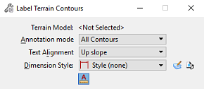
Tool Settings
|
Settings |
Description |
|
Terrain Model |
Name of the selected terrain model. |
|
Annotation mode |
All Contours places a label on all selected contours. Major Contours Only places labels on major contours. |
|
Dimension Style |
Sets the current dimension style from a list of all available dimension styles. To create or select a dimension style, click the Magnifying Glass icon to open the Dimension Styles dialog. To restore any dimension-related tool settings to the default dimension style settings, click the Reset style icon. |
|
Text Alignment |
Up Slope orients the text labels to always read as though you are standing at the bottom of a hill and looking uphill. Follow Line orients the text labels so the direction of the line used to select the contours determines text orientation. |
|
Height |
Sets the text height, in working units. The default is set by the text style. |
|
Width |
Sets the text width, in working units. The default is set by the text style. |
|
Annotation Scale Lock icon |
If on, makes the contour annotations use the active model annotation scale. |

