Create From Graphical Filter
 Creates a terrain using
previously defined graphical filters, which determine the candidate elements
for triangulation.
Creates a terrain using
previously defined graphical filters, which determine the candidate elements
for triangulation.
You can access this tool from the following:

Data may be provided for consumption into the terrain model in a variety of formats including raw graphical elements both 2D and 3D. For the Create Terrain by Graphical Filter, the elements must be 3D. The tool is useful when the source data has consistent (standardized) element symbology. Rather than defining the element symbology for each terrain feature each time a terrain model is created, the information can be stored in a filter group. Numerous groups can be stored in a dgnlib, so the user merely selects the appropriate group, based on the type of features and associated symbology. If none of the groups are applicable, a new filter group can easily be created.
The advantage of the Create Terrain by Graphical Filter tool is that numerous terrain features can be imported simultaneously; the user does not have to select each feature individually, as with the Create Terrain by Elements tool. However, there must be consistency in the source data to utilize this tool.

|
Settings |
Description |
|
Append to Terrain |
Toggle on if there is already a terrain model in the file (or referenced) and the data is to be added to the selected TM. |
|
Graphical Filter Group |
Select the filter group from the list. If no filter groups are defined in the file or dgnlibs, a prompt is displayed indicating there are none, and the Graphical Filter Manager dialog opens. Note one the filter group is created, the user is returned to the Create TM dialog. |
|
Opens the Terrain Filter Manager. |
|
|
Preview |
Click to highlight any element in the view that matches the filter. |
|
Ignore Feature Linking |
The Ignore Feature Linking option is an override to the Link to Terrain Features in the Terrain Filter Manager dialog. When toggled off, the setting in the Link to Terrain Features within each filter is utilized. When toggled on, the Link to Terrain Features setting within each filter is ignored and the terrain model is created unruled. |
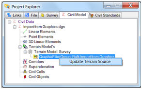
Update Terrain from Source
Terrains that have been created using graphical filters retain the creation rule on the Terrain. This is accessible in Project Explorer under the Civil Model > Terrain Models. Mouse selection of the Rule allows updating of the Terrain Source. The update reprocesses the rule and adds any additional graphical elements that have been added.
|
Prompt |
User Action |
|
Append to Terrain |
Toggle on if there is already a terrain model in the file (or referenced) and the data is to be added to the selected TM. |
|
Graphical Filter Group |
Select the filter group from the list. If no filter groups are defined in the file or dgnlibs, a prompt is displayed indicating there are none, and the Graphical Filter Manager dialog opens. Note one the filter group is created, the user is returned to the Create TM dialog. |
|
Opens the Graphical Filter Manager. |
|
|
Preview |
Click to highlight any element in the view that matches the filter. |
|
Terrain Features |
Don't Link Feature Graphics The terrain model is created from the graphics but there is no association maintained with the graphic. Thus, if the graphic is edited later, the terrain model will not update. It will have to be regenerated. Use this option for faster performance. Link Graphic Features The terrain model is created and ruled to the graphic elements. Thus, edits to the graphic immediately update the terrain model. Using this option on large datasets takes a significantly longer time to build the terrain model. The DGN is scanned and the first 15,000 elements found are added to the rule that is attached to the terrain model that gets created. Changing one of these elements affects the terrain model. All other elements found in the DGN are added into the terrain model but not added to the rule. Changing one of these elements does not affect the terrain model. A warning displays in the Civil Message Center if the limit is reached. |