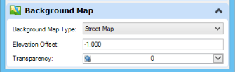
View Attributes Dialog, Background Map Section
Contains controls to set the background map. Background maps very easily display either a street map, aerial imagery, or hybrid imagery (streets and street names superimposed on aerial imagery) to be used as background for any 2D or 3D design model that has a Geographic Coordinate System attached. Microsoft Bing maps are used for the background data.
The background map settings are saved to the view undo buffer, so the View Previous and View Next tools work for the maps. The background map settings are saved to saved views, and applied when a saved view is applied.
When a background map is displayed in a view, the reset pop-up menu contains the Show Background Map Providers option. Selecting it opens an information window displaying the imagery providers.
| Setting | Description |
|---|---|
| Background Map Type | Allows you to select the type of background map to be displayed. Options are None, Street Map, Aerial, and Hybrid. |
| Elevation Offset | (Available only for 3D design model) Defines the distance above or below the Z=0 plane at which the background data is drawn. For 3D data, it depends on the elevation of the data in the model. |
| Transparency | Allows you to set the transparency of the background data. |