Connect
The Connect command connects and draws a strand line between two poles on the active file or across a reference file if using DGN persistence.
Connect Two Poles
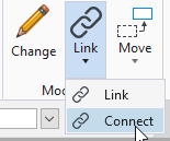
- From the Facilities Tab, select Connect in the Modify/Delete section:
- Select and accept the first pole to be connected.
- The Strand Length dialog box opens.
- Key in a distance and select the next pole to which the connection is being made.
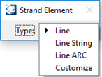
- The Strand Element dialog box opens.
- Choose a line type and press Enter.
- Place the length text if poles are on the same map.
Connect to a Pole or Pedestal on a Reference Map
In DGN persistence mode, when connecting to a pole or ped on a reference map, a match line needs to be created. The match line must be a line element not a shape element for the command to work.
- From the Strand Module menu, click the Connect button.
- Select and accept the first pole to be connected.
- The Strand Length dialog box opens.
- Key in a distance and select on the reference map the next pole to which the connection is being made.
- The Strand Element dialog box opens.
- Choose a line type and press Enter.
- Select the match line (between the active and reference file) or press Reset to create a new match line by using two data points.
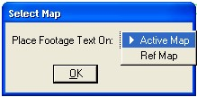
- Determine which map (active or reference) is associated with the length text.
- Click OK to confirm.
- Place the length text on the reference map.