Known Issues
The following sections contain information about known issues in this OpenCities Map release. You should report any other issues found while using this software. Please do not assume that others will report the information. However, it is not necessary to report any of the known issues described on this page.
| Description | Resolution |
|---|---|
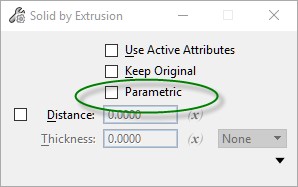
| OpenCities Map currently does not work with the new Parametric Solids. | When creating solid geometry, toggle off Parametric option. The Solid by Extrusion tool is shown below. If you have created 3D models with the Parametric settings, you can drop them to regular solids by using the Drop Element with the Application Elements option checked. |
| Publishing i-models or i-models for Map Mobile is not available. | |
| After modifying the size of a text sub-feature, all added features disappear when applying thematic symbolization. | This problem is intermittent and is under investigation. There is no workaround. |
| The variable GDI_PARTIAL_POSTING_MAX_ERRORS is being ignored. Spatial partial posts are occurring in situations where valid elements are being posted and the maximum number of errors is being exceeded. This also occurs with the keyin 'gdi set partialPostingMaxErrors=n' | Verify spatial posting operations are complete by querying the data immediately after the posting operation. |
| When using the delivered Geo_Example project and the Dialogs workset, the grid property is not being displayed for Open Winform dialog example. | |
| When display rules are applied to a display style, polygon collections will not render correctly when the view is changed. This includes panning. | |
| OpenCities Map PowerView does not support Work in Markup Mode. | |
| The Legend Options dialog may not always display when using the Print Preparation tool. | |
| The Date data type does not work properly when creating a thematic definition in the Map Manager that uses a Where clause. | |
| Files created by Bentley Map Mobile having the extension "markupdb" cannot be opened directly. To open files of this type, rename the extension to "idgndb". | |
| In High Security mode, some drop down menus in the ribbon are not working. | |
| When Flip Coordinates is enabled in the WFS Connect dialog, it will be applied to all WFS connections in your current design session. To clear this option from your design session you must restart Map. | |
|
The variable MS_TASKNAVIGATION_CONFIGURATION has been deprecated. |
|
| Grids and Graticules functionality was added to OpenCitiesMap CONNECT Edition Update 4. However, the implementation did not correctly interpret grid definitions created in Bentley Map V8i. | Grid definitions made with previous editions of OpenCitiesMap CONNECT must be recreated for use with Update 5. |