New and Changed in OpenCities Map CONNECT Edition Update 7
Product re-branding within the Bentley software catalog is taking place in order to provide clarity and consistency across the naming of desktop applications. Products that are affected include those sold in Suites, Tiers, and Enterprise Editions, such as the OpenCities Map products, beginning with this Update 7 commercial release.
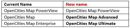
OpenCities Map products have been offered in a three-tiered approach from the beginning - OpenCities Map PowerView, the most basic version of the application; OpenCities Map, for users who mainly work with 2D and need to update spatial databases, and OpenCities Map Enterprise, the most comprehensive version of the product that adds full support of 3D. The Enterprise Edition also comes with a complete version of MicroStation and Descartes.
The new names will establish consistency across all products in the Bentley catalog. The basic version name will remain the same. The intermediate version will have the word "Advanced" appended to it. The most comprehensive version will no longer be referred to as an Enterprise edition and have "Ultimate" appended to it.
Therefore, the new names for the OpenCities Map products will be:
These other enhancements have been added to OpenCities Map CONNECT Edition Update 7:
- Re-branding
- DGN2DB
- Place by Command Key-in Metadata
- See the Resolved Issues in Update 7 list in the Bentley Communities for more details regarding fixes to existing commands
About Technology Preview Features
The following features in this update are provided as Technology Preview:
- Labeling has several enhancements such as: specifying label frequency, specifying area type to label, trimming labeled elements to the view, containing labels within a closed element, and setting the maximum label size factor.
- Label Collision Detection to detect and resolve text conflicts.
- Export Feature Definitions
- The New Live Feature
Detection Rules dialog.
- It is now possible to create rules to determine which feature definition a CAD element will be inferred as.
- It is also possible with the rules to set property values for the inferred feature based on information extracted from the CAD element.
- This tool is in the Map Admin Workflow of the OpenCities Map Ribbon