Create Style

To create a new cartographic style, select the Create tool from the Cartographic Styles ribbon group or from the Cartographic Styles Manager.
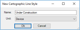
In the New Cartographic Line Style dialog, enter a name and specify the units. Device units are relative to the screen. Master units are in the units of the DGN file. Device units are typically used as they have a common thickness regardless of zoom scale. This is the same behavior as MicroStation's default line weights.
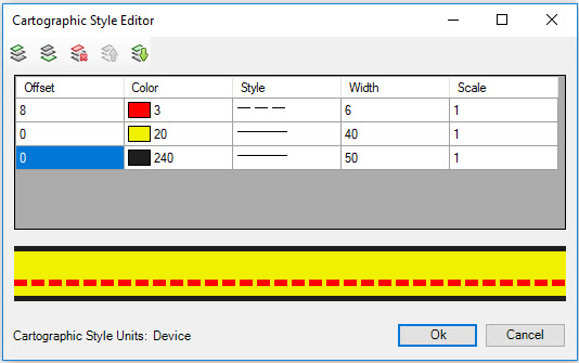
The Cartographic Style Editor dialog opens which provides tools to customize each component of the new cartographic style. A style is defined by creating the individual components of the cartographic style from the bottom up. The effect is similar to layering ribbons of varying widths and colors on top of one another.
The following tools are used to control the order of each linear component of the cartographic style:
| Name | Icon | Description |
|---|---|---|
| Add Over |
Adds a new line entry above the selected line. |
|
| Add Under |
Adds a new line entry below the selected line. |
|
| Delete |
Deletes the currently selected line. |
|
| Move Up |
Move the selected line up. |
|
| Move Down |
Move the selected line down. |


The following options are used to customize each components symbology and to specify the distance its offset from the center.
| Column | Operation |
|---|---|
| Offset |
The distance in units up or down from center. Positive numbers offset down, negative numbers offset up. |
| Color |
The color of the line. |
| Style |
The style of the line. |
| Width |
The width in units of the line. |
| Scale |
Scales the width and style by the value entered. |
Selecting OK will add the new style to the current model.
In the following example, the cartographic style is composed of three lines:
- A black line with a width of 50 units.
- A yellow line with a width of 40 units that is placed on top of, and centered on the black line.
- A red dashed line with a width of 6 units placed on top of the yellow line and offset 8 units from the center.