Note: Split Polygon 3D
is only available in the
OpenCities Map Ultimate edition of this
product.
Use the Split Polygons feature to split a closed element
in two. If the split element had properties, then the new elements will have
those same properties. Any annotation for the initial element will be deleted.
New annotation can be added for each new element by using the edit tool, making
any changes to the properties and placing the new annotation.
Valid closed elements are: Shape, Complex Shape, Ellipse,
Group Hole, 2D Polygon Collection, 3D Polygon Collection.
Valid cut line elements are: Line, Linestring, Complex
Line.
The following tool settings are available in a 2D model:
| Setting
|
Description
|
| Polygons Selection
|
If an existing selection set of closed elements
is not found, then this setting describes how the elements are selected.
- By
User - Prompts you to select a closed element. Multiple elements can be
selected with a datapoint. When all elements are selected, enter a datapoint in
the view followed by a reset. This is the default setting.
- By
Cut Line - Splits selected elements at the location of a cut line. The cut line
can be drawn interactively when Draw Cut Line is on, or be an existing linear
element that passes through the selected elements.
|
| Draw Cut Line
|
When on, draw a cut line that
defines the split location for the selected element. When off, select an
existing cut line that defines the split location for the selected elements.
|
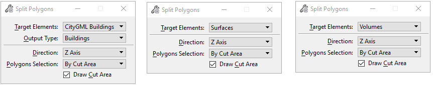
The Split Polygon tool supports 3D non-planar closed
polygons. The following tool settings are available in a 3D model:
| Settings
|
Description
|
| Target Elements
|
Specifies which elements to split.
- Surfaces - Valid features are polygons
and any polygon collection.
- Polygon Collections - All faces inside
the cut area will be added to the first collection. All faces outside the cut
area will be in the second collection.
- Polygons - All polygons touched by the
cut area perimeter are split into two or more polygons. All polygons completely
inside or outside the cut area are unchanged.
- Volumes - Valid features are
watertight polygon collections. Invalid features are polygon collections that
are not watertight or that are not polygons. The resulting collections will be
watertight. If needed, extra faces will be created and added to the collection.
All polygon sections in the cut area will be in the first collection. All
polygon sections outside the cut area will be in the second collection.
|
| Direction
|
Specifies the direction of the
split. Closed views are shown in gray.
|
| Polygons Selection
|
If an existing selection set of closed elements
is not found, then this setting describes how the elements are selected.
- By
User - Prompts you to select a closed element. Multiple elements can be
selected with a datapoint. When all elements are selected, enter a datapoint in
the view followed by a reset.
- By
Cut Area - Splits target elements based on the location of a cut area. The cut
area can be drawn interactively when Draw Cut Area is on, or be an existing
closed element that passes through the target elements.
|
| Draw Cut Area
|
When on, draw a cut area that
defines the split location for the target elements. When off, select an
existing closed that defines the split location for the target elements.
|
Note: If a split rule is
defined in the feature definition, then that rule will be applied when setting
the new polygons properties. See the
OpenCities Geospatial Administrator section of this help for
details.
To split polygon collections when:
- Polygon
Selection is set to By Cut Area
The Split Polygon tool allows you to split one or more
polygon collections that lie partially within a cut area. The cut area can be
defined by an existing shape or by datapoints. The general steps are defined as
follows:
- If Draw Cut
Area is off, identify an existing shape. Accept with a datapoint.
- If Draw Cut
Area is on, enter data points to define the cut area. Reset to complete the
shape.
- All polygon
collections that intersect with the cut area are split.
To split polygon collections when:
- Polygons
Selection is set to By User
The Split Polygon tool allows you to split one or more
polygon collections. The identification of polygon collections is determined by
entering a datapoint within the boundaries of one shape belonging to the
collection. The general steps are defined as follows:
- Select a shape
that belongs to the first polygon collection.
- Accept the
selection with a datapoint, and optionally select a shape belonging to another
polygon selection.
- Continue to
accept and select the shapes until all polygon collections have been
identified.
- Accept the
last selection with a datapoint.
- Press Reset to
complete the selection process. The selected polygon collections will be
highlighted.
- Split Polygon
will then prompt to place or select the cut area.
- If Draw Cut
Area is enabled, enter data points to define the cut area. If Draw Cut Area is
not enabled, select an existing closed element that defines the cut area.
- Press Reset
to complete.
- The selected
polygons are split.
Key-ins:
SPLITMERGE SPLIT
SPLITMERGE SPLITTOOLSETTINGS