Cartographic Styles
Cartographic styles are used to enhance a map by improving the appearance of linear elements and the intersections of those elements. Cartographic Styles do not create new elements, instead the representation is for display purposes only.

Cartographic styles are assigned to linear features by editing their symbology in the Map Manager. When the Symbology Type is set to Cartographic Styles, a cartographic style can be selected from a list of available cartographic styles. The cartographic styles listed are those found in the current model or configured DGNLib. Several standard styles are provided in linestyles.dgnlib which is located in ...\geo_example\designer\dgnlib\. To use these styles, copy this file to the dgnlib folder of your workspace.

Cartographic styles also includes the ability to resymbolize linear features that represent bridges.
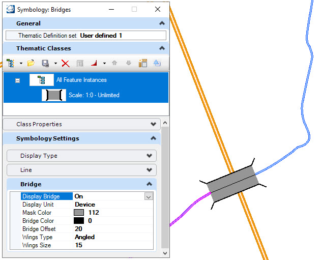
For example, enable bridge display and adjust the following settings:
| Setting | Description |
|---|---|
| Bridge Display | Enables or disables the display of bridges. |
| Display Unit | Set the units to use as device units or master units. Set the units to use as device units or master units. |
| Mask Color | Determines the color of the mask which covers overlapping elements. |
| Bridge Color | Sets the bridge color. |
| Bridge Offset | Sets the offset distance from the linear element used to define the bridge. The larger the number, the wider the bridge. |
| Wings Type | Sets the wing style for the ends of the bridge. The options are: None, Angled and Perpendicular. |
| Wings Size | Sets the size of the wing when Angled or Perpendicular are specified as the wing type. |
The tools to create and manage cartographic styles are found in the Cartographic Styles ribbon group of the Map Admin workflow.

| Name | Icon | Description |
|---|---|---|
| Create Style | Creates a new cartographic style in the current model. | |
| Duplicate Style | Creates a copy of the selected style and appends 'Copy' to the name. | |
| Edit Style | Opens the Cartographic Style Editor dialog. | |
| Delete Style | Deletes the selected cartographic style from the current model. | |
| Import Style | Imports cartographic styles from another model into the current model. |


These tools area also available in the Cartographic Styles Manager which is selected from the dialog launcher. The Cartographic Styles Manager is used to view, manage and edit cartographic styles with the provided tools. A preview of the selected style is displayed at the bottom of the dialog. Styles defined in a file located by the variable MS_DGNLIBLIST and are displayed in grey. Cartographic Styles in the current model are displayed in black.
