Support Non-Planar Shapes
Support for non-planar shapes is specific for feature definitions of type Polygon or Polygon Collection. The toggle buttons value determines the Plane Constraint options.
Note: For a registered feature class, the value of this toggle would be stored in the feature’s registration information in the ECRelationalDbMapping class property allowNonPlanar.
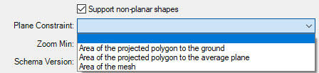
For a polygon feature definition, with Support non-planar shapes turned on:
- Area of the projected polygon to the ground - Flattens the non-coplanar polygon geometry to the XY plane/top view when calculating the area.
- Area of the projected polygon to the average plane - The polygon is projected on the average plane in the direction perpendicular to the average plane.
- Area of the mesh - Area of the polygon mesh when calculating the area.
For a polygon feature definition, with Support non-planar shapes turned off:
- Area of the projected polygon to the ground - Flattens the non-coplanar polygon geometry to the XY plane/top view when calculating the area.
- Area of the polygon - Area of the polygon mesh when calculating the area.
For a polygon collection feature definition, with Support non-planar shapes turned on:
- Area of the projected polygon collection to the ground - Flattens the non-coplanar polygon geometry to the XY plane/top view when calculating the area.
- Total of the areas of the projected polygon to the average plane per polygon - Flattens the non-coplanar polygon geometry to an average plane when calculating the area.
- Total of the areas of the meshes - Totals the area of each mesh when calculating the area.
For a polygon collection feature definition, with Support non-planar shapes turned off:
- Area of the projected polygon collection to the ground - Flattens the non-coplanar polygon geometry to the XY plane/top view when calculating the area.
- Total area of all polygons - Totals the area of each mesh when calculating the area.
For a registered feature class, the value of this drop-down list would be used to determine the value of the isHorizontal property in the ECRelationalDbMapping class of the feature’s registration information. The allowNonPlanar and isHorizontal property values are used during posting to Oracle when validating geometry. When allowNonPlanar is True/ON, and isHorizontal is set as:
- False, then geometry validation is not performed.
- True, then geometry validation is performed with Oracle validation mode which is more forgiving with non-coplanar geometry.
When allowNonPlanar is False/OFF, then geometry validation is performed normally, meaning with whatever validation their database supports by default (e.g., 11g, 12c, 18c).