Importing CSV and ODBC Data Sources
OpenCities Map's can import features maintained in CSV (Comma Separated Values) text files or ODBC (Open Database Connectivity) data sources by using a VRT (Virtual File Format) file.
A VRT file is a text file that describes the point, linear or polygon import data. It includes information regarding the geometry type, the coordinates, the feature name and the spatial reference system of the layer.
A VRT file has an extension of the VRT and should be in the same folder as the source data.
A sample VRT file might look like the following:
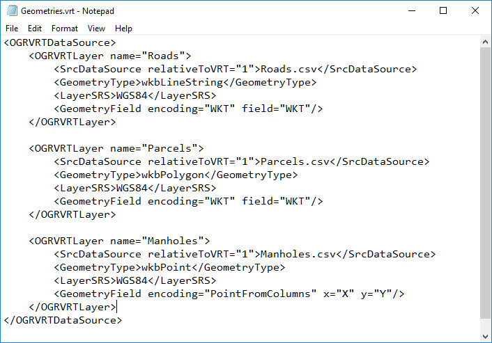
Where:
OGRVRTLayer defines the name of the feature layer.
SrcDataSource defines the source data which would be a CSV file, or named ODBC data source. SrcDataSource expects the source data to be located in the same folder as the VRT file. If the file is in another folder then preface the file name with a fully qualified directory path.
GeometryType specifies whether the data is point, linear or polygon.
LayerSRS defines the geographic coordinate system (GCS) for the data. It can refer to an existing GCS found in the Bentley library or can describe a GCS using WKT syntax. An example is below.
<LayerSRS>PROJCS ["LA83-SF" [GEOGCS ["NAD83", DATUM ["North American Datum of 1983", SPHEROID ["GRS 1980 (EPSG ID 7019)", 6378137.0, 298.257222101]], PRIMEM [ "Greenwich", 0.000000 ], PROJECTION ["Lambert_Conformal_Conic"],PARAMETER["Standard_Parallel_1",30.7],PARAMETER["Standard_Parallel_2",29.3],PARAMETER["Central_Meridian",-91.3333333333333],PARAMETER["Latitude_Of_Origin",28.5],PARAMETER["False_Easting",3280833.333],PARAMETER["False_Northing",0], UNIT ["Foot_US",0.30480060960121924]]]]</LayerSRS>