Overlay (Topology Analysis)
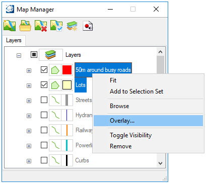
An overlay is the combination of two layers to create a new feature instance. The source layers and processing options determine which feature properties are kept. The overlay option is available when two features are selected in the Map Manager and at least one of them is a polygon.
Two Polgyons - When both layers are polygons, the Polygon Operation section is active in the Topology Analysis dialog. The resulting overlay will contain the feature instances and properties of the first layer.
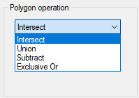
- Intersect - Only areas that are inside both layers will be saved.
- Union - All of the areas of both layers will be saved.
- Subtract - The second layer will be subtracted from the first layer, and the resulting areas saved.
- Exclusive Or - The areas that are not common to both layers will be saved.
Linear or Point and Polygon - When one of the selected layers is a point or linear layer and the other is a polygon, the "Linear / Point Operation section is active.
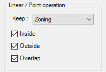
Keep - Specifies which layer to keep. Depending upon the layer selected, the definition of the parameters are as follows.
- If the layer to keep is a
polygon:
- Inside - Finds all polygon instances that include at least one feature instance of the other layer.
- Outside - Finds all polygon instances that do not include any feature instances of the other layer.
- Overlap - Finds all polygon instances that overlap with at least one feature instance of the other layer.
- If the layer to keep is not
a polygon:
- Inside - Finds all linear (or point) instances that include at least one feature instance of the polygon layer.
- Outside - Finds all linear (or point) instances that are completely outside of the feature instances of the polygon layer.
- Overlap - Finds all linear (or point) instances that are overlapping the feature instances of the polygon layer.
If a linear or point layer is one of the layers to be overlaid, then the layer name to be saved must be selected. The spatial location of features with regard to the polygon layer can also be selected, whether they are inside, outside, or overlapping the selected layer.
Example with two polygons:
- In the Map Manager, select a layer or layers (up to two) to overlay.
- Right-click on one layer and select Overlay. The Topology Analysis dialog opens.
- If the correct layers to be overlaid are not selected, then select them from the left and move them to the Layers to be overlaid list with the arrows. Only two layers can be overlaid at one time.
- Select the operation to perform on the layers. The icon shows how the resulting layer will be produced.
- Type a name for the overlay in the Result field.
- Click Ok.

The overlay tool creates a new feature class in the Map Manager using the name specified in the Topology Analysis dialog. The resulting elements are placed on the active level using the active symbology. These new elements can be edited as required using the element manipulation tools. The symbology can be adjusted using the Map Manager. Feature properties can be reviewed and editing.