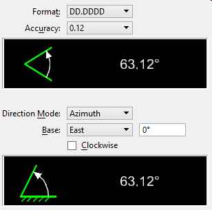
| Format |
Sets the angle readout format:
- DD.DDDD — Decimal degrees (for example, 65.4290°).
- DD MM — Degrees and minutes.
- DD MM SS — Degrees, minutes, and seconds.
- Gradians
- Radians
|
| Accuracy |
Sets decimal accuracy up to eight decimal places for angles. |
| Direction Mode |
Sets the manner in which angles are measured:
- Azimuth — Clockwise from the design plane positive y-axis; used in disciplines such as astronomy, surveying, and navigation.
Azimuth Angle Mode
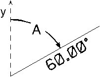
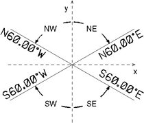
- Bearing — Angles are measured as follows:
| Quadrant |
Direction |
From Axis |
| Northeast |
Eastward (clockwise) |
North |
| Northwest |
Westward (counterclockwise) |
North |
| Southeast |
Eastward (counterclockwise) |
South |
| Southwest |
Westward (clockwise) |
South |
Reads out: <distance> <axis> <angle> <direction>, where:
| Read Out |
Description |
| <distance> |
The length of the terminal side |
| <axis> |
Axis (N or S) from which angle is measured |
| <angle>° |
The angle |
| <direction> |
Direction (E or W) in which angle is measured |
A sample bearing readout is "3.5, N 45°E." The terminal side lies in the quadrant identified by the bearings (the northeast quadrant in this example).
Bearing Angle Mode
Note: The Active Angle is defined conventionally regardless of the Angle Mode setting.
|
| Base |
Sets the base direction for angle readout to North, South, East or West. To specify a different direction, choose Custom and enter a value. |
| Clockwise |
If on, sets the sweep orientation used for direction readout in the clockwise direction. |
| Preview box |
The proposed angle displays in the preview area. The thick line shows the base direction. |