Design File Settings Dialog, Working Units Category
Consists of controls that are used to set "real world" units of measurement for your design models. The product recognizes Metric and English units, either of which may be selected from option menus. You also can create your own custom units by relating them to the standard units (Metric or English). Changing between the units used in a model makes no difference to the size of geometry in your model. Changing the Resolution setting in the Advanced settings does change the size of existing geometry in the model. In practice, the Resolution setting rarely, if ever, has to be changed from the default.
You can have different Working Units assigned to different models that are contained in one DGN file.
When you define new Working Units, you must select from the ribbon (or the shortcut <Ctrl+F>) to save the new settings.
| Setting | Description |
|---|---|
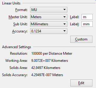
| Linear Units | Sets the format, units, and accuracy for linear units in a model. |
| Format | Sets the display format for linear units.
Note: In DWG workmode, Format can be set to Architectural, Decimal, Engineering, Fractional, and Scientific. The Format setting controls the Master Unit, Sub Unit, and Accuracy settings. For example, when the Architectural or Engineering format is selected, the Sub Unit setting is used, rather than the Master Unit setting. Each of these items is enabled/disabled with workmode capability variables.
|
| Master Unit | Lets you select, from an option menu, the largest unit in common use in the model. |
| (Master Unit) Label | Lets you set the standard abbreviation for the measuring unit selected as the Master Unit. By default, the software suggests a label when you select the Master Unit. For example, if the Master Unit is Meters then the default Label is m. If required, you can key in a substitute label. |
| Sub Unit | Lets you select, from an option menu, the smallest convenient unit to use in the model. The Sub Unit must be smaller than the Master Unit chosen. For example, if the Master Unit is Meters then the Sub Unit might be Centimeters, or Millimeters. |
| (Sub Unit) Label | Lets you set the standard abbreviation for the measuring unit selected as the Sub Unit. By default, a label is suggested when you select the Sub Unit. For example, if the Sub Unit is Centimeters, the default Label is cm. If required you can key in a substitute label. |
| Accuracy | Sets decimal accuracy up to six decimal places for coordinates, eight decimal places for scientific accuracy, eight decimal places for angles, or fractional accuracy to 1/2, 1/4, 1/8, 1/16, 1/32, or 1/64. |
| Custom | Opens the Define Custom Units dialog, which lets you create customized definitions for Master Unit and/or Sub Unit. Tip: Another way to define custom units is to use a units definition file. The units defined in a units definition file are available during a session. They can be selected in the same way as standard units. If a unit from the unit definition file conflicts with one of the standard units, the unit from the definition file is used. The active unit file is defined by the configuration variable MS_CUSTOMUNITDEF. The default file is units.def located in
..\Default\Data\
in OpenCities Map's program directory. This file includes the syntax and examples of custom unit definitions.
|
| Advanced Settings | Display the settings for the resolution of the design environment. Clicking Edit opens the Advanced Unit Settings dialog, which lets you change the resolution settings. |