| Name
|
Used to enter a name for the site.
|
| Location
|
Contains site data that allow you to define the
project location on the globe and to select the most appropriate weather
profile data.
- Continent — Used to
select the continent in which the site is located. By default, the continent
property is determined by the settings in the Defaults
Manager dialog box. Use the drop-down list to select the continent applicable
to your project site. The continent selection made here filters the Country
drop-down list to display only the countries located on the selected continent.
- Country — Used to
select the country your site is located in.The selection made here filters the
State/Province drop-down list to display only the states or provinces located
in the selected country.
- State/Province —
Used to select the state or province your site is located in. The selection
made here filters the Location drop-down list to display only the weather
locations found in the selected state or province.
- Location — Used to
select the nearest weather station to your project site.
- Weather profile —
Used to select the weather profile for the project site. The project’s
available weather profiles appear on the drop-down list, which have been loaded
into the project using the
Weather Manager's
Copy to Project option.
- Longitude —
Displays the longitude value for the site location. The Longitude property is
read only.
- Latitude — Displays
the latitude value for the site location. The Latitude property is read only.
- Altitude — Displays
the altitude value for the site location. The Altitude property is read only.
- Mains Water
Temperature — Used to set the temperature of the water supplied to the project
building’s piping from the local water utility's distribution mains.
|
| Atmospherics/Climate
|
Contains properties that allow you to define the
specific atmospheric conditions prevalent at your project site based on the
weather data selected for the project.
- Clarity — Used to
set the level of atmospheric clarity for the site. For calculations involving
solar gains, solar radiation intensity is computed using atmospheric
turbidity. The specified atmospheric clarity for the site will fix the sky
turbidity.
- Undefined
- Very clear
- Clear
- Urban
- Industrial
- Special – When
selected, summer and winter turbidity values are considered.
- Turbidity winter —
Used to view or modify the amount of cloudiness due to particles in the air for
winter calculations.
- Turbidity summer —
Used to view or modify the amount of cloudiness due to particles in the air for
summer calculations.
- Climate Zone &
Moisture Zone — Used to set the climate and moisture zones in which the project
site is located. Climate zones are specified with a number (1 through 8) and
moisture zones, a letter (A, B or C).
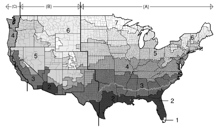
The
2006 International Energy Conservation Code (IECC) Climate Zone map of the
continental United States of America
- Direct solar
correction factor — Used to view or modify the factor used to create an
estimation of direct solar radiation without using any meteorological
parameters or measurements which requires only geographical input parameters
such as longitude and altitude of a location.
- Diffused solar
correction factor — Used to view or modify the factor used to create an
estimation of diffused solar radiation without using any meteorological
parameters or measurements which requires only geographical input parameters
such as longitude and altitude of a location.
|
| Terrain
|
Contains properties that allow you to define the
physical terrain prevalent at the site location. The terrain properties are
used to determine the factors define the amount of wind and solar energy
absorbed and lost at the site.
|
| Daylight saving
|
Contains properties used to set daylight savings
data for the project. You can use daylight saving for the project if required.
Using daylight saving will introduce a time difference between actual time
(e.g. occupancy times) and solar time. The dates of daylight saving and the
time difference are defined with the weather data for the location.
- Use daylight
savings — When on, daylight savings time is considered for all calculations and
simulations performed on the project.
- Start day — Used to
define the start date for use of daylight savings time. Clicking on the Start
date opens a pop up calendar to use for changing the date.
- End day — Used to
define the end date for use of daylight savings time. Clicking on the End date
opens a pop up calendar to use for changing the date.
|