Create Clipped Terrain Model tool
Used to create a new terrain model by clipping a previously created terrain model.
Found on the Civil ribbon in the Terrain Model group.
The Create Clipped Terrain Model creates a new terrain model by clipping a previously created terrain model. Note that a copy of the original terrain is created. The data in the original terrain does not change.
The clipping element must be drawn prior to commencing clipping and can be any type of closed area. Use a MicroStation closed object for clipping.
Tool Settings
| Setting | Description | ||||||
|---|---|---|---|---|---|---|---|
| Reference Terrain Model | Select the terrain model or mesh to be clipped. | ||||||
| Clipping Method |
|
||||||
| Horizontal Offset | The Horizontal Offset affects the clipping limits. If it is toggled off, then the closed polygon is used as the clipping limits. If the Offset is toggled on, then the polygon is moved out similar to doing a copy parallel with the offset value. | ||||||
| Vertical Offset | The Vertical Offset moves the resultant terrain model up (positive value) or down (negative value) by the offset distance, in terms of master units. It does not change the clipping limits. | ||||||
| Feature group |
|
Clipping Limits
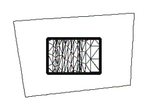
The first graphic below depicts the original terrain model. In the middle of the model, a closed area has been placed, denoted with heavy black lines.

The following show the effects the different Clipping Method options have.

Internal - results in a void created in the resultant terrain model.