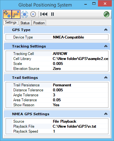
| GPS Type |
Defines the GPS device as NMEA-Compatible, Garmin USB, or Windows Location Services. |
| Tracking Settings |
Defines the settings used in tracking mode.
- Tracking Cell — Specifies the cell used to track the current position. If the cell is not specified or found, tracking cannot start.
- Cell Library — Specifies the cell library in which to search for the tracking cell. If this field is empty, MicroStation searches
SystemCells.dgnlib
.
- Scale — Defines the scale of the tracking cell. When set to 1, tracking cell display is actual size. When viewing a large area and your scale size is small, setting the Scale larger makes the GPS tracking cell more visible.
- Elevation Source — Specifies the elevation at which the tracking cell is displayed. In a 2D model, the only option is Zero. In a 3D model, the Fixed option lets you enter the elevation; the From GPS option pulls the elevation from the connected GPS device.
|
| Trail Settings |
Determines points added to the trail as the GPS position changes.
- Trail Persistence — Specifies the lifetime of the generated trail. The While On option erases the GPS trail as soon as trailing is turned off. The Session option keeps the trail until you exit or view a different model. The Permanent option writes the trail as a line string to the active model.
- Distance Tolerance — Determines where to save a point on the trail. When the current GPS position exceeds the Distance Tolerance from the previously saved point, a new point is saved. Distance Tolerance is entered in the same units as the active model's master units.
- Angle Tolerance — Determines where to save a point on the trail. If the angle formed by the current GPS position and the two preceding GPS position readings exceeds the Angle Tolerance, a point is saved at the previous GPS position (the vertex of the angle). Angle Tolerance is entered in degrees.
- Area Tolerance — Determines where to save a point on the trail. When the area formed by a triangle, consisting of the current position's vertex and the last two saved positions, exceeds the area tolerance the current position is saved to the trail. Area Tolerance is entered in square master units.
- Show Reason — Shows the criteria used to determine the GPS trail points in the Status bar.
|
| Garmin USB Settings |
Displays when Device Type is set to Garmin USB.
- Source — Defines the GPS source as USB Device, a live GPS device connected to your computer, or as File Playback, a Garmin USB GPS previously recorded using the GPS Recorder.
- Playback File — Specifies the GPS recording file, if Source is set to File Playback.
- Playback Speed — Sets the speed at which to play back the GPS recording file. 1.0 plays the file back at the speed it was recorded.
|
| NMEA GPS Settings |
Displays when Device Type is set to NMEA-Compatible.
- Source — Defines the GPS source as Serial Port, a live GPS device connected to your computer, or as File Playback, an NMEA-compatible GPS previously recorded using the GPS Recorder. If File Playback is chosen, the Playback File and Playback Speed fields specified in Garmin USB Settings display.
- Comm Port Number — Specifies the serial port where the GPS is connected, if Source is set to Serial Port. For Bluetooth devices, this field must be set to the COM port used as the virtual serial port.
- Baud Rate — Specifies the baud rate of the GPS device. Ignore this field when using a Bluetooth device.
|
| Windows Location Services Settings |
Displays when Device Type is set to Windows Location Services.
- Source — Defines the GPS source location from Windows Location Services or as File Playback.
- Playback File — Specifies the GPS recording file, if Source is set to File Playback.
- Playback Speed — Sets the speed at which to play back the GPS recording file. 1.0 plays the file back at the speed it was recorded.
|