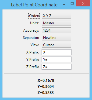
Label Point Coordinate
 Used to label coordinate points in the design by entering a data point. Coordinate labels are placed in the design as text nodes. When ACS Lock is enabled, this tool labels the coordinates based on the Active ACS.
| Setting | Description |
|---|---|
| Order | Defines the order in which the labeled point displays — XYZ or YXZ. |
| Units | Defines the coordinate format. Options are: Master, Sub, Working, and UORs. |
| Accuracy | Specifies the unit of accuracy for displaying the point coordinates. |
| Separator | Defines the coordinate delimiter. Options are: Newline, Comma, and Space. |
| View | Allows you to choose a view's orientation to display the coordinates. (Only affects 3D files.) |
| X Prefix, Y Prefix, Z Prefix | Allow you to specify the prefix for the x, y, and z coordinates respectively. The x, y, and z status fields at the bottom of the settings window dynamically display the x, y, and z coordinates of the current pointer location. |
Note: Depending on how many elements you are labeling, or depending on the size of the elements, you may want to change the point size of the coordinate's text (see Text Styles).