| Raster List |
List of rasters for which to set the Attachment Options. If all selected rasters cannot be attached, the attachment options for these rasters are not visible and the Attach button is greyed out.
If a raster cannot be attached as requested, the icon on the left of the raster's name will be replaced by a warning icon.
Raster with the warning icon:
- Will be attached but not as requested.
- To view the "Error Details", select this menu item in the contextual right click menu.
- You can modify the attachment settings of these rasters to make them attachable. For example: inadequate read/write settings can be modified.
- If the error message is ignored, by default the raster will be attached in read-only mode.
If a raster cannot be attached at all, the icon on the left of the raster's name will be replaced by an error icon and the file name will be displayed in red.
Rasters with the error icon:
- Will not be attached.
- To view the "Error Details," select this menu item in the contextual right click menu. For example: if attempting to attach a HMR file while in DWG work mode, the message will explain the problem and will propose to remove the rasters from the list.
- The attachment options for these rasters are not visible.
- If the error message is ignored, by default the raster will NOT be attached
A raster can be removed from the list by selecting the "Remove" item in the contextual (right-click) menu.
For multi-page rasters, a sub tree can be expanded. By default the first page is always selected. To select another page, choose the "Page selection" item in the contextual (right-click) menu and select a page number in the Select Pages dialog. This dialog is divided in two, with the list of available pages on the left (the selected page is highlighted) and a preview of the last selected page on the right. Multiple selections are possible.
|
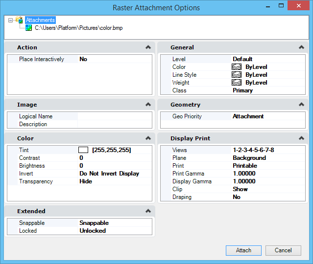
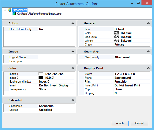
| Action |
- Place Interactively — Sets the value of the "Place Interactively" toggle located in the Attach Raster Reference dialog. The toggle is initialized with this value when a DGN is opened. If the value is changed, it is preserved until a new DGN is loaded. It is possible to place multiple selections interactively. Optionally, selections can be placed by using two or three points. Default: Off
|
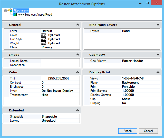
| General |
- Level — This is the standard list box to select a level. The user can select any existing level attached to the current DGN. If the "Use Active Level" field is set to ON in the Preferences, this field is initialized with the current active level each time it is opened. The user can then modify this field for the current attachment. If the "Use Active Level" field is set to OFF in the Preferences, this field is initialized with the level specified in the Preferences, each time it is opened. The user can then modify this field for the current attachment.
- Color — Use to set the raster border color. When the "Use Active Color" field is set to ON in the Preferences, this field is initialized with the current active color each time it is opened. The user can then modify this field for the current attachment. When the "Use Active Color" field is set to OFF in the Preferences, this field is initialized with the color specified in the Preferences, each time it is opened. The user can then modify this field for the current attachment.
- Line Style — Use to select the raster border line style. When the "Use Active Line Style" field is set to ON in the Preferences, this field is initialized with the current active line style each time it is opened. The user can then modify this field for the current attachment. When the "Use Active Line Style" field is set to OFF in the Preferences, this field is initialized with the line style specified in the Preferences, each time it is opened. The user can then modify this field for the current attachment.
- Weight — Use to select the raster border line weigh. When the "Use Active Line Weight" field is set to ON in the Preferences, this field is initialized with the current active line weight each time it is opened. The user can then modify this field for the current attachment. When the "Use Active Line Weight" field is set to OFF in the Preferences, this field is initialized with the line weight specified in the Preferences, each time it is opened. The user can then modify this field for the current attachment.
- Class — This is the standard list box to select the element class. When the "Use Active Class" field is set to ON in the Preferences, this field is initialized with the current active class each time it is opened. The user can then modify this field for the current attachment. When the "Use Active Class" field is set to OFF in the Preferences, this field is initialized with the element class specified in the Preferences, each time it is opened. The user can then modify this field for the current attachment.
- Priority — This is the standard list box to select the display priority. This field will not be visible if one of the selected rasters is not on the design plane. When the "Use Active Priority" field is set to ON in the Preferences, this field is initialized with the current active priority each time it is opened. The user can then modify this field for the current attachment. When the "Use Active Priority" field is set to OFF in the Preferences, this field is initialized with the priority specified in the Preferences, each time it is opened. The user can then modify this field for the current attachment.
|
| Bing Maps Layers |
(Available only when a Bing Maps reference is attached) Allows you to select the type of Bing Maps layer:
- Road — a cartographic type map with roads and place names
- Aerial — aerial photography of the earth
- Aerial with labels — a hybrid of aerial photography and roads and place names
|
| Image |
- Logical Name — The logical name must be unique. Therefore, this field will not be displayed when more than one raster is selected. When only one raster is selected, it will be possible to edit the field to give a logical name to the file. This logical name will be validated as soon as the focus leaves the field. If the name is not unique, a warning will display.
- Description — This field is left free for the user to enter a description of this attachment.
|
| Geometry |
This section is hidden if the "Place Interactively" toggle is turned ON in the Attach Raster Reference dialog.
- Geo Priority — Use to change the georeference from Sister File to Image Header or Attachment. Sister File : also relates to World File, same constraints as for Raster Header geopriority when read-only is set ON.Raster Header: file location found in raster header takes priority, some raster manipulations (move, scale, rotate) are blocked if the raster with this geopriority is set to read-only. Attachment: file location found in attachment takes precedence and raster header information does not get destroyed.
- Inherit GeoCS from Model — If selected, the geocoordinate system is inherited from the Model. Not available if the "Place Interactively" toggle is turned ON in the Attach Raster Reference dialog or if the raster reference does not support geocoding.
|
| Color |
- Tint — Use to add a tint to the colors in the raster image. Opens the standard color picker without the palette tab. (Not for binary files).
- Contrast — Use to adjust the contrast for the display of raster image files. Values can vary from -100 to 100. (Not for binary files).
- Brightness — Use to adjust the brightness for the display of raster image files. Values can vary from -100 to 100. (Not for binary files).
- Index 1 — Opens the Active Color dialog used to set the color of Index 1. For binary files only.
- Index 0 — Opens the Active Color dialog used to set the color of Index 0. For binary files only.
- Background Index — Use to select the Background Index (Index 1 or Index 0). For binary files only.
- Invert — For monochrome images, the Foreground Color setting controls the color of foreground items and the Background Color setting is used to set the background color of the raster file. Use to invert the Foreground and Background colors.
- Transparency — Use to enable or disable transparency settings.
|
| Display Print |
- Views — Numbered push buttons let you define in which view(s) to display the raster reference(s). Note that the raster may not display in the view selected here, if the view is closed or if the view does not currently display the model to which the raster has been attached.
- Planes — Use to select in which plane (Background, Design or Foreground) the raster reference(s) display(s).
- Print — Use to determine whether the raster reference(s) will be "Printable" or "Not Printable".
- Invert Print — Use to determine whether to "Invert Print" or "Do Not Invert Print". (For binary files only).
- Print Gamma — Use to set the gamma correction value for the printer. Values can vary from 0.01 to 256. (Not for binary files).
- Display Gamma — Use to set the display gamma correction value. Values can vary from 0.01 to 256. (Not for binary files).
- Clip — Use to show or hide the clipping polygon for raster references that have been clipped.
- Drapable — Use to determine whether the raster will be drapable or not. Available only if the raster file is being attached to a 3D DGN.
|
| Extended |
- Snappable — Use to determine whether the raster will be "Snappable" or "Not Snappable". Default: Snappable.
|