Geographic Coordinate Systems Fundamentals
Although the earth is nearly spherical in shape, humans and computer programs such as MicroStation prefer to work in a two dimensional or three dimensional Cartesian coordinate system. A cartographic projection is required to convert spatial data coordinates, which are latitude and longitude, to a Cartesian coordinate system.
Unprojected Geographic Data
The simplest Geographic Coordinate System is to simply use latitude/longitude values as Cartesian coordinates. The problem is that the results of that transformation process do not provide a meaningful way to visualize distances, areas, or angular relationships between geographic features.
To see why this is so, observe that on Earth, distance between lines of longitude (easting) decreases as one moves from the equator toward the poles. Latitude (northing) values remain equally spaced. Therefore, if you use longitude as the X Cartesian value and latitude as the Y Cartesian value, the resulting map is distorted, as you can see from this map of North America plotted with such unprojected coordinate system.
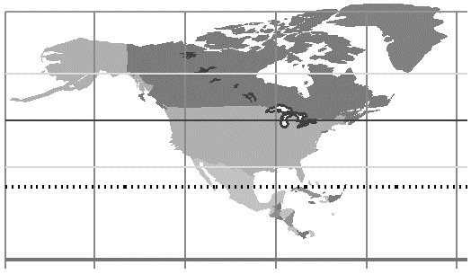
No meaningful decisions could be made based on information obtained from this map. Distances cannot be measured, shapes are not accurate, and areas are not reliable. While there may be situations in which you will want to use latitude and longitude coordinates in your data system, the analysis, interpretation and decision making process requires the spherical geographic data be flattened by a cartographic process.
Projected Data
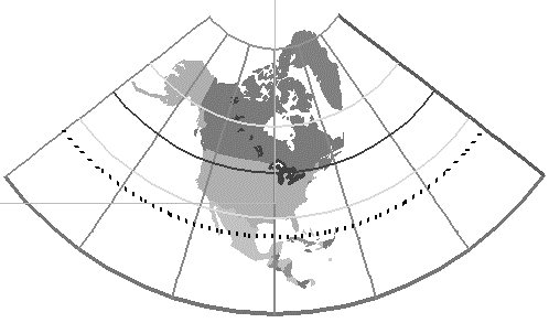
Using well-designed cartographic projections, we can transform longitude and latitude to Cartesian coordinates with much lower distortion of distances, shapes, and areas. Compare the map of North America with the unprojected map and you will see the difference.
A GIS system is not only flat, it is Cartesian. It requires X’s and Y’s where the X-axis is orthogonal to the Y-axis and every unit of X is the same size as every other unit of X and Y. Generating a Cartesian image of geographic data inside a GIS system is the same as committing it to a piece of paper, except we just omit the final step of plotting it. A projection is involved but there is a bit more to making a map than just a projection. What we require is a Coordinate System definition that involves the use of a projection.