Cylindrical Projections
In order to create a more accurate map, we need to get more of the photographic film closer to the surface we are mapping.
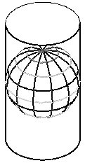
Gerardus Mercator did exactly this in 1569. His idea was to take our film and wrap it around the Earth in the form of a cylinder. In doing so, the film actually touched the earth on the whole extent of the equator.

Anywhere close to the equator, the lines are crisp and clean, indicating a minimum of projection distortion. As we move away from the equator, the lines begin to get fuzzy. As we approach the poles, the lines disappear altogether. These are the underlying features of the standard Mercator projection which has been used for years to create maps of the entire world.
We can take a flat piece of photographic film and make a cylinder out of it. Once this cylindrical shaped film is positioned on the Earth, a picture can be taken. Unrolling the cylinder produces a flat surface, which becomes our map. The important concept here is that a cylinder, while round in one dimension, can be easily converted to a perfectly flat surface. A surface which has this characteristic is said to be a developed surface.