| Import / Export icon |
Use to import from or export to a file the current parameters.
|
| Style |
-
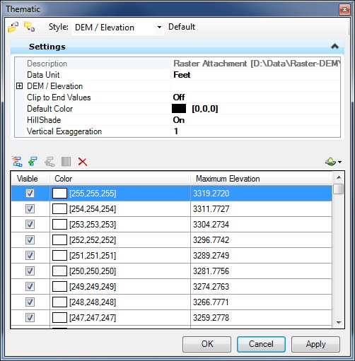
DEM / Elevation — Maps color to elevations ranges of the selected raster surface(s).
-
DEM / Slope — Maps color to slopes ranges of the selected raster surface(s).
-
DEM / Aspect — Maps color to slope orientations ranges of the selected raster surface(s).
- GRID / Intensity — Maps color to the intensity of the selected raster surface(s).
|
| Settings |
-
Description — File path of the raster attachment.
-
Data Unit — Units used to store the elevations in the file. If the file has no units, ?? will be displayed in the field.
-
DEM / Elevation, DEM / Slope, DEM / Aspect and GRID / Intensity — Minimum and maximum values of the current thematic style. If the values are unknown, Unknown will be displayed in the fields.
-
Clip to End Values — Defines how the highest and lowest class are interpreted. If set to ON, the values smaller than the lowest class and higher than the highest class will not be included in any class. If OFF, the values lower than the lowest class and higher than the highest class will be included in those classes.
-
Default Color — Color used to display pixel elevations that are not included in any visible class.
-
Hillshade — Use to enhance the display by simulating shading effects caused by lighting. Can be turned ON or OFF.
-
Vertical Exaggeration — This option only has visual effect if the Hillshade is set to ON.Increment to increase the shadow effect.
|
| Generate Classes icon |
Opens the Class Generator dialog which is used to generate a new set of classes based on different parameters.
|
| Add Class icon |
Adds a new class at the top of the list.
|
| Insert Classes icon |
Available only when two (and only two) consecutive classes are selected in the list. This tool also opens the Classes Generator dialog which is used to generate new classes in between the selected classes.
|
| Ramp Colors |
Use to select the ramp colors.
|
| Delete Selected icon |
Deletes the selected classes in the list.
|
| Hillshade Options icon |
Used to set the Azimuth and Altitude Hillshade options. These options are not defined per attachment, but is a global setting for all rasters surfaces attachments.
|
| Classes list box |
The classes list has three columns:
-
Visible — Use to turn ON or OFF the display of the selected class.
-
Color — Use to define the color of the class. Edit the color by clicking on the color chooser in this field.
-
Maximum Elevation — Maximum value (included) of the range for that class. The minimum value is defined by the maximum value (not included) of the class below. Double-click on the values to edit.
-
Merge — Access through the contextual (right-click) menu only when more than one class is selected. Used to merge the selected classes.
|