Export Point Cloud tool settings
After accepting the operation with a data point, the Export Point Cloud dialog opens, which allows you to export and save to the LAS, XYZ or POD format.
The precision of XYZ export is governed by a variable.
POINTCLOUD_XYZEXPORT_NBDECIMALS = integer. The value can be 1 through 8 and represents the number of decimal places exported when selecting XYZ format. The default value is 4.
A file will be created for each tile that has point cloud data within the extent of the tile.
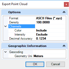
| Setting | Description |
|---|---|
| Format |
ASCII, LAS or POD. |
| Classification Filter |
The classifications to be exported. |
| Density |
A percentage value indicating the density of the export. |
| Channels |
Selects the channels to include in the export (color, intensity and classification). |
| Geometry Unit |
The value for the geometry unit. |
| Decimal Accuracy | The decimal precision of the exported values. Higher precision increases the size of the output file. |
| Point Filter |
Indicates that the classifications from the point filter file should be applied on export. |
| Reproject |
Reproject the points according to the selected geographic coordinate system. |