Extract Elevation Points
The Extract Elevation Points tool extracts a grid of elevation points and their labels from Scalable Meshes.
Access the tool:
- Realty Modeling workflow: Extract tab > Scalable Mesh > Extract Elevation Points.
- Open Reality Mesh Attachments dialog then select Tools.
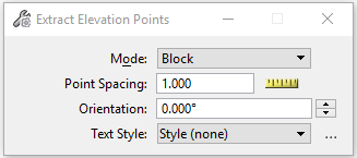
| Setting | Description |
|---|---|
| Mode: | Choose area where to extract elevation points: |
| Point Spacing | Sets the interval between rows and columns of extracted elevation points grid pattern. |
| Orientation | Sets the orientation of the extracted elevation points grid pattern relative to the x-axis of the selected coordinate system. |
| Test Style | Sets the current text style from a list of all
available text styles.
To create a new text style, click the browse icon next to the Text Style option menu to open the Text Styles dialog. To restore any text-related tool settings to the default text style settings, click the Reset Style icon. |
KEY-IN: SCALABLEMESH EXTRACTELEVATIONPOINTS
KEY-IN: SCALABLEMESH EXTRACTELEVATIONPOINTS BLOCK
KEY-IN: SCALABLEMESH EXTRACTELEVATIONPOINTS ORI_BLOCK
KEY-IN: SCALABLEMESH EXTRACTELEVATIONPOINTS SHAPE
KEY-IN: SCALABLEMESH EXTRACTELEVATIONPOINTS ELEMENT
KEY-IN: SCALABLEMESH EXTRACTELEVATIONPOINTS REALITYMESH