Additional data
The Additional data tab allows you to edit or display additional knowledge on the acquisition which is used to help aerotriangulation.
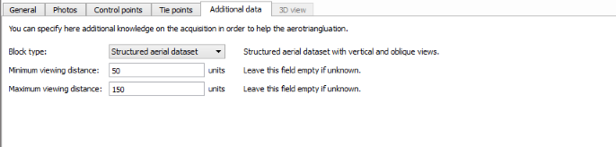
Block type
This advanced option allows you to specify some typical
acquisition types:
- Generic (default): advised for most image datasets.
- Vertical views only:
advised for any aerial image dataset made of vertical views only (pointing
toward the bottom).
Also named Nadir block type.
- Structured aerial
dataset: advised for structured aerial image datasets only, with vertical and
oblique views acquired with a regular sweep of the area in parallel lines, and
sensors with fixed lever arm angles.
Also named Aerial block type.
- Orbit around thin vertical
structure: advised for dataset made of orbital views around a thin structure or
around a thin vertical subject of interest in the foreground (telecommunication
tower, pylon, wind turbine, etc.).
Also named Orbit block type.
Minimum/maximum viewing distance
If your knowledge about the viewing distance is approximative, please take an appropriate margin (reduce the minimum viewing distance and increase the maximum viewing distance accordingly).
When the photo positions are known, the minimum and maximum viewing distances can be used during aerotriangulation to discard inadequate pairs of photos and improve performance.