Spatial Reference System
Georeferenced project requires to define a cartographic system by selecting a Spatial Reference System (SRS) at the reconstruction (Spatial framework) and production levels.
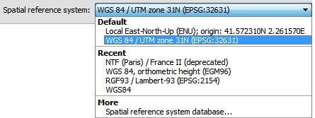
The interface used for Spatial reference system choice proposes a default selection adapted to the context, a list of recent choices, and a direct access to the Spatial reference system database for more choice.
Spatial reference system database
In the spatial reference system list, click on More: Spatial reference system database to access the database.
The database proposes more than 4000 spatial reference systems and is extensible with custom user definitions.
Spatial reference systems are sorted by type:
- Cartesian systems: 3D cartesian coordinate systems, including ECEF (geocentric) and Local East-North-Up (ENU) coordinate system.
- Geographic systems: coordinate systems based on a spheroid, for instance the WGS 84 latitude/longitude coordinate system.
- Projected systems: map projections sorted by projection type (UTM, Lambert Conformal Conic, etc.). Projected systems also include the specific Web map projection Bing Maps system.
- User defined systems: custom user definition.
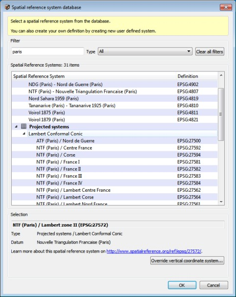
Use the filter to quickly find an existing Spatial reference system in the database and select an item in the filtered table.
For specific types of systems you may be asked to enter additional parameters:
- Local East-North-Up (ENU): needs latitude and longitude of the origin. See also ENU (on page 13).
- Bing Maps system: needs level of detail from 1 to 23. See also Bing Maps Tile System.
User defined system: needs name and definition (see after).