Surveys
The Surveys tab allows you to edit or display the survey data attached to a block: Survey points and positioning constraints
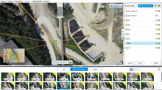
Survey points are optional positioning data used during the aerotriangulation of the block.
Two types of survey points can be added:
- Control points - allow to enter known 3D coordinates of one point located on photos and are used to register the 3D scene.
- Tie points - allow to identify one point on photos and are used to create positioning/scaling constraint, or to stitch photos.
Survey points can also be used after the aerotriangulation to identify positions on photos and to perform Quality control (on page 141).
Positioning constraints are position/orientation/scale priors based on user tie points. They are used during the aerotriangulation of the block.
Surveys data can be optionally extracted from photos in an automatic way using targets (see Aerotriangulation).