Add point clouds
Importing point clouds Limitation: ContextCapture only supports point clouds with known scan source positions. Moreover, if scan source positions specified in the imported point cloud are incorrect, it will adversely affect the 3D reconstruction or even cause a completely incorrect 3D reconstruction.
Static scans
Point clouds can be imported from static scans in the following file formats:
- ASTM E57 file format (.e57).
- Cyclone point cloud export format (.ptx).
- LAS/LAZ file format (.las, .laz), When specifying a scanner position.
When importing a georeferenced point cloud file, please specify the spatial reference system when importing the file. Multiple files can be imported at once.
The user can specify a manual scanner position by checking the corresponding option. Manual scanner position is mandatory for .las and .laz files. When specifying a manual scanner position, only one file can be imported at once.
Mobile scans
Point clouds can be imported from mobile scans in the following file formats:
- ASTM E57 file format (.e57) with trajectory files.
- LAS/LAZ file format (.las, .laz) with trajectory files.
- NavVis PLY format (.ply).
According to the format, the trajectories must be provided as separated text files (.txt or .csv) describing successive scanner positions associated with time. ContextCapture integrates a text file import wizard to extract trajectory data for various text formats.
3D points of the provided point clouds must also include time data to be attached properly to the trajectories.
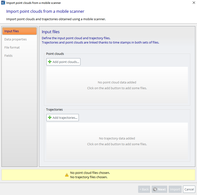
Input files
Define the input point clouds and trajectory files. Trajectories and point clouds are linked through the time stamp in both sets of files.
File format
Define how the trajectory files must be read. You can adjust the import parameters, so that each column in the Data preview table contains meaningful information:
- Number of lines to ignore at the beginning of the file: defines the length of the file header and ignores it during import.
- Delimiters: defines the column separators. Several characters can be specified. The option Combine consecutive delimiters can be required, for instance when sequences of white spaces are used as delimiter.
- Decimal separator: dot (123.456) or comma (123,456).
Data properties
When importing a georeferenced point cloud file from mobile scans, please specify the suited spatial reference system. Note that the point clouds and the trajectories must be in the same spatial reference system.
Fields
Specify role of columns for the trajectory data. You must associate each input column with its respective role. X (easting), Y (northing), Z (height/altitude) and time are required.