Exporting Spatial reference system
Projected, geographic or user defined spatial reference systems can be exported in standard PRJ files including the WKT definition.
Right-click on an item and choose Export to create a PRJ file.
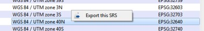
Exporting SRS allows to adjust a SRS definition externally or export a user defined SRS to another computer.
Vertical coordinate system
Geographic and projected systems use the datum on which they are based as height reference (ellipsoidal height).
For convenience you can override the vertical coordinate system to use another reference for heights.
 Some vertical coordinate system
definitions are based on geoid approximation subject to sampling and
interpolation, resulting in loss of vertical accuracy.
Some vertical coordinate system
definitions are based on geoid approximation subject to sampling and
interpolation, resulting in loss of vertical accuracy.
Click on Override vertical coordinate system to select a new reference for heights.
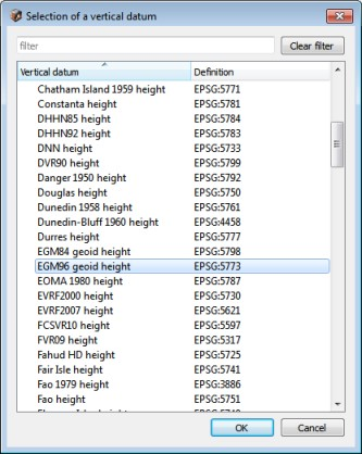
Upon confirmation of your choice, a new user defined system is created with the overridden vertical coordinate system.
Note: Using EGM96 geoid as vertical coordinate system allows to get a good approximation of mean sea level (MSL) heights.
User defined system
To Create a Custom Spatial Reference System (SRS) (on page 173).
To find a spatial reference system, you can visit http://www.spatialreference.org/.
PROJ.4
PROJ.4 declaration allows to enter a custom projection system (for instance "+proj=utm +zone=11 +datum=WGS84").
See also http://trac.osgeo.org/proj/wiki/GenParms.
Well Known Text (WKT)
OpenGIS Well Known Text format for coordinate systems can be provided in an attached PRJ file. In such case, enter the projection file path as SRS definition (for instance "C:\projections\myProjection.prj").
Example of WKT definition contained in a PRJ (.prj) file:
GEOGCS["WGS 84",
    DATUM["WGS_1984",
                       SPHEROID["WGS 84",6378137,298.257223563,
            AUTHORITY["EPSG",7030]],
        TOWGS84[0,0,0,0,0,0,0],
        AUTHORITY["EPSG",6326]],
    PRIMEM["Greenwich",0,AUTHORITY["EPSG",8901]],
    UNIT["DMSH",0.0174532925199433,AUTHORITY["EPSG",9108]],
    AXIS["Lat",NORTH],
    AXIS["Long",EAST],
    AUTHORITY["EPSG",4326]]
Additional data
Some spatial reference systems use external dependencies which, prior to their use, must be installed in the "data\gdal" subdirectory of ContextCapture installation directory.
For instance, a spatial reference system with a custom vertical coordinate system may use a GTX grid to approximate the geoid.
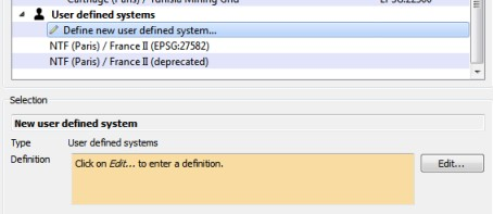
Create custom spatial reference systems
- Select the item Define new user system to start the creation of a new spatial reference system.
- Click on Edit to define the new spatial reference system.
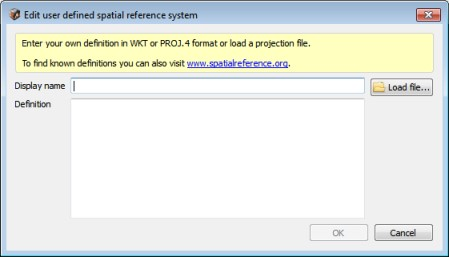
- Enter a display name and the
definition of the new user defined system.
Any well known SRS definition can be entered, which includes PROJ.4 declarations, Well Known Text (WKT), or the name of a PRJ file containing a definition.
To find a spatial reference system, you can visit www.spatialreference.org.