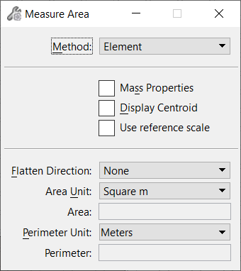
| Method
|
Sets the area that is measured.
- Element - Area of
one closed element (its Area attribute must be Solid). It is the planar area of
shapes, ellipses, and complex shapes. For 3D surfaces or solids, it is the
total surface area in all dimensions.
- Fence - (Fence
present only) Area enclosed by the active fence, other than a named fence, or a
fence created from an element.
- Intersection - Area
bounded by the intersection of two or more closed planar elements.
Where more than two elements are involved, use <Ctrl+data
point> to select the extra elements.
- Union - Area bounded
by the union of two or more closed planar elements.
Where more than two elements are involved, use <Ctrl+data
point> to select the extra elements.
- Difference - Area
bounded by the difference between two or more closed planar elements.
Where more than two elements are involved, use <Ctrl+data
point> to select the extra elements.
- Flood - Area
enclosed by elements that either touch one another or whose endpoints fall
within the Maximum Gap.
- Points - Planar area
with its vertices defined by a series of data points. Where the points are
input in a figure 8 type shape, then the total area of the two loops is
calculated.
|
| Mass Properties
|
If on, the mass property analysis displays in the
Mass Properties window.
|
| Display Centroid
|
If on, a graphic crosshair that represents the
measured element's center of mass is displayed.
|
| (Technology Preview) Use reference scale
|
Allows users to measure in true model units while in a Sheet
model that contains a scaled reference file. This checkbox is off by default.
Note: Fence and Flood options are not supported. This setting is
only applicable in the Sheet models.
|
| Flatten Direction
|
Sets how measurements for area are reported.
- None - Measures the
true area in 2D and 3D sheet and design models.
- View Z - Measures
the projected area based on the view rotation. Not recommended for use in 3D
design models. For 3D data referenced to a 2D Design model or 2D sheet model or
3D sheet model the projected distance is reported.
- ACS Z - Measures
about the active Auxiliary Coordinate System (ACS) or in the ACS XY plane.
Results are projected about the ACS Z or on the ACS XY plane.
- AccuDraw Z -
Measures about the AccuDraw compass XY or about AccuDraw Z. Results are
projected about the AccuDraw Z or on the AccuDraw XY plane.
|
| Area Unit
|
Sets the units used to display the last area
measured.
- square m - (Metric
units only) Square meters.
- Acre (US) - (English
units only)
- Hectare - (Metric
units only)
|
| Area
|
Displays the result of the last area measured.
|
| Perimeter Unit
|
Sets the units used to display the perimeter length
for the last area measured.
|
| Perimeter
|
Displays the perimeter length for the last area
measured.
|
| Locate Interior Shapes
|
(Method set to Flood only) If on, the area enclosed
by the bounding elements is calculated, minus the area of any closed elements
inside the bounding area.
|
| Dynamic Area
|
(Method set to Flood only) If on, the area to be
included displays dynamically as you move the screen pointer over the view.
|
| Max(imum) Gap
|
(Method set to Flood only) Sets the largest distance
allowed between consecutive elements. If zero, the elements must connect to
bind an area.
|
 Used to measure area and
perimeter.
Used to measure area and
perimeter.